This post is based primarily on Don's notes, occasionally supplemented with MT's notes from our cruise in August 2022. When information from other sources is added—for further explanation to readers or to satisfy our own curiosity—that is set off in a text box (as this one).
Most of the photos that accompany this post are from Don’s camera (with a caption indicating the time it was taken); those from MT’s iPhone are indicated by “MT” placed at the beginning of the photo caption. Photos from any other source (such as the public domain Wikimedia Commons), occasionally used for clarification, indicate that source in the caption.
Most of the photos that accompany this post are from Don’s camera (with a caption indicating the time it was taken); those from MT’s iPhone are indicated by “MT” placed at the beginning of the photo caption. Photos from any other source (such as the public domain Wikimedia Commons), occasionally used for clarification, indicate that source in the caption.
The Viking Daily newsletter showed today's weather forecast as "Sunny 88° F."
According to the travel requirements listed in the My Viking Journey web site, we were required to get an electronic visa for Turkey.
.PNG)
Don's electronic visa (with date of birth and passport number blacked out here).
We woke around 6:15 am.
Around 7 am, the Viking Sky arrived at the port of Kusadasi, Turkey.
Turkey (Turkish: Türkiye), officially the Republic of Turkey, is a
transcontinental country located mainly on the Anatolian Peninsula of Western
Asia with a small portion on the Balkan Peninsula of Southeast Europe. This
area has been inhabited since Neolithic times. Following the conquests of
Alexander the Great in 334 BC, most of the ancient regions in modern Turkey
were Hellenized, which continued during the Byzantine era. Beginning in the
late 13th century, the Ottomans] period began. During the reign of Suleiman the
Magnificent, the Ottoman Empire became a world power. Starting in the late 18th
century, that empire’s power declined, with a gradual loss of territories. It
entered WWI as part of the Central Powers. After that alliance was defeated,
the Ottoman Empire was partitioned. In 1923, the Republic of Turkey was
proclaimed, with Mustafa Kemal Ataturk as its first president.
Kuşadasi is a large resort town on Turkey’s Aegean coast and the center of a seaside district of the same name. The municipality’s main industry is tourism.
Kuşadasi is a large resort town on Turkey’s Aegean coast and the center of a seaside district of the same name. The municipality’s main industry is tourism.
We went to breakfast in the World Café on Deck 7 around 7:30. We actually ate on the open-air Aquavit Terrace on the aft end of Deck 7. But, before eating, MT took some photos as we were coming into Kuşadasi, where we were scheduled to arrive around 7:00 am.

MT Wednesday, August 24, 2022, 6:27 AM - Kuşadasi: sunrise from Aquavit Terrace on Deck 7 of Viking Sky (mild telephoto 43 mm).

MT 6:28 AM - Kuşadasi: view of town, with statue of Ataturk on hill above large sign for Kuşadasi, from Aquavit Terrace on Deck 7 of Viking Sky (telephoto 80 mm).

8:01 AM - Kuşadasi: view of town from Aquavit Terrace on Deck 7 of Viking Sky.

8:02 AM - Kuşadasi: view of town, with statue of Ataturk on hill above large sign for Kuşadasi, from Aquavit Terrace (mild telephoto 58 mm).

8:05 AM - Kuşadasi: view of town, with statue of Ataturk on hill above large sign for Kuşadasi, from Aquavit Terrace (telephoto 130 mm).

MT 8:05 AM - Kuşadasi: Don and view of town, with statue of Ataturk on hill above large sign for Kuşadasi, from Aquavit Terrace (mild telephoto 36 mm).

MT 8:10 AM - Kuşadasi: Don and MT and view of town, with statue of Ataturk on hill above large sign for Kuşadasi, from Aquavit Terrace (mild telephoto 40 mm).

8:02 AM - Kuşadasi: Port of Kuşadasi (sign on large building), from Aquavit Terrace.
At 9:15 am, we went to the pier for our optional shore excursion "Ancient Ephesus."
The My Viking Journey web site described the optional shore excursion Ancient
Ephesus as follows:
Price: $79.00 USD
Duration: 3.50 Hours
Date: August 24, 2022, 09:45 AM
A Tour of This Fascinating Ancient City -- Explore one of the best-preserved cities of antiquity in the world as you walk the length of ancient Kuretes Street. Stroll from Ephesus’s upper gate to its lower gate. Join your guide on a scenic drive through the stunning countryside of Selçuk to the Magnesian Gate, the ancient city entrance at the top of Kuretes Street. Then follow a gently descending route through one of the Roman Empire’s most powerful outposts. Navigate some steps along the way, passing the finely crafted 2nd-century Temple of Hadrian and the spectacular Great Theater, able to host 25,000 spectators. Marvel at the most recognizable building in the city, the Library of Celsus, built to house 12,000 scrolls. Its colonnaded facade is an outstanding example of a typical Roman public building. You will have free time to browse the craft stalls at the lower gate before returning to your ship.
The Viking
Daily newsletter also had the following description of “Ephesus (Kuşadasi,
Turkey", with no mention of Kuşadasi:
“One of antiquity’s best-preserved cities, Ephesus offers an unparalleled look into the lives of the ancients. Many of its ruins have endured from the time Ephesus was one of the largest metropolises of the ancient world. Excavations reach back to the 10th century BC, when this city hosted one of the Seven Wonders of the Ancient World—the Temple of Artemis. Today, Ephesus is still full of wonders: the towering façade of the Library of Celsus, the massive amphitheater that once sat 25,000 spectators and residences adorned with frescoes. Ephesus also holds an important place in Christianity. Here, St. John is said to have preached and Mary to have lived out her final days in a tiny stone house.”
“One of antiquity’s best-preserved cities, Ephesus offers an unparalleled look into the lives of the ancients. Many of its ruins have endured from the time Ephesus was one of the largest metropolises of the ancient world. Excavations reach back to the 10th century BC, when this city hosted one of the Seven Wonders of the Ancient World—the Temple of Artemis. Today, Ephesus is still full of wonders: the towering façade of the Library of Celsus, the massive amphitheater that once sat 25,000 spectators and residences adorned with frescoes. Ephesus also holds an important place in Christianity. Here, St. John is said to have preached and Mary to have lived out her final days in a tiny stone house.”
Our guide for the "Viking Sky 23" tour group was Suzetta (Suzy for short). First, we took a bus from the port at Kuşadasi to the Ephesus archaeological site.
Ephesus (Greek: Ephesos) was a city of ancient Greece
on the coast of Ionia. It was built in the 10th century BC by Greek and Ionian
colonists. During the Classical Greek era, it was one of the twelve cities that
were members of the Ionian League. The city came under Roman control in 129 BC.
In its day, the city was famous for the nearby Temple of Artemis (completed
around 550 BC), which was one of the Seven Wonders of the Ancient World.
The city was destroyed by the Goths in 263 AD. Although it was subsequently rebuilt, its importance declined as a result of its harbor being slowly silted up by the Küçükmenderes River.
The city was destroyed by the Goths in 263 AD. Although it was subsequently rebuilt, its importance declined as a result of its harbor being slowly silted up by the Küçükmenderes River.
The distance from Kuşadasi harbor to the Ephesus archaeological site is 18-19 km (about 12 mi).

10:07 AM - Ephesus: near entrance of archaeological site, at top of Kuretes (Curetes) Street.

MT 10:05 AM - Ephesus: near entrance of archaeological site, at top of Kuretes (Curetes) Street; our guide Suzy with flowered parsol.

10:07 AM - Ephesus: near entrance of archaeological site, at top of Kuretes (Curetes) Street; our guide Suzy with flowered parasol in right foreground.

MT 10:14 AM - Ephesus: view ahead to the Odeon (theater) on right side of street of Kuretes (Curetes) Street (mild telephoto 37 mm).

10:08 AM - Ephesus: view ahead to the Odeon (theater) on right side of street (telephoto 93 mm).
The Odeon
was a small, roofed theater constructed around 150 AD. Seating about 1,500, it
was used for small plays and concerts. There were 22 stairs in the theater. The
upper part of the theater was decorated with red granite pillars in the
Corinthian style.

10:08 AM - Ephesus: our guide Suzy with her flowered parasol; the Odeon in background on right side of street.

10:11 AM - Ephesus: arches of Bath of Varius.
The Baths
of Varius, near the main entrance of the Ephesus archaeological site, is a
complex marble structure located north of the State Agora (Ephesus had two agoras,
one for commerce and the other for state affairs). It was built around the 2nd century
AD, in the Roman period, and was restored several times through the centuries.
The excavations have not been completed, and no restoration has been undertaken.
The famous sophist Flavius Damianus built the original bath. This would have been a great mark of status, since the Romans valued personal hygiene and would have used these baths on a regular basis. It was built at the main entrance in order to help visitors freshen up and rest before proceeding into the city. Greco-Roman baths also served a social function as a meeting and massage destination.
The famous sophist Flavius Damianus built the original bath. This would have been a great mark of status, since the Romans valued personal hygiene and would have used these baths on a regular basis. It was built at the main entrance in order to help visitors freshen up and rest before proceeding into the city. Greco-Roman baths also served a social function as a meeting and massage destination.
Kuretes (Curetes) Street runs from near the Baths of Varius, at the entrance to ancient Ephesus, east-northeastward to the Library of Celsus.

MT 10:14 AM - Ephesus: arches of Bath of Varius (mild telephoto 37 mm).

10:11 AM -
Ephesus: columns of Upper (State) Agora in front of Odeon.

10:14 AM -
Ephesus: sign for "ODEON Concert Hall" pointing to right from street.

10:16 AM -
Ephesus: Christian symbol of an eight-spoked wheel and Greek letters ἸΧΘΥΣ
(IKhThUS) carved into stone.
The Greek
word ἸΧΘΥΣ (IKhThUS or ICHTHUS) means “fish.” The image of a fish or the
word itself was adopted by early Christians, during the time of Roman
persecution, as a secret symbol to determine if another person was indeed
Christian. The word is an acronym for "Ἰησοῦς Χρῑστός Θεοῦ Υἱός
Σωτήρ" (Iēsoûs Khrīstós, Theoû Huiós, Sōtḗr), which translates into
English as “Jesus Christ, God's Son, Savior.”
A 4th-century adaptation of ichthus uses a round shape to represent the letters “ἸΧΘΥΣ” in the eight lines that bisect the shape. Most often, this shape has been interpreted as an eight-spoked wheel.
A 4th-century adaptation of ichthus uses a round shape to represent the letters “ἸΧΘΥΣ” in the eight lines that bisect the shape. Most often, this shape has been interpreted as an eight-spoked wheel.

MT 10:17 AM - Ephesus: Christian symbol of an eight-spoked wheel and Greek letters ἸΧΘΥΣ (IKhThUS) carved into stone.

MT 10:20 AM - Ephesus: our guide Suzy said this was some sort of a game carved into stone.

10:19 AM - Ephesus: pieces of columns and one capital.

10:19 AM - Ephesus: bulls' heads and sign for "BOULEUTERION."

10:22 AM - Ephesus: sign for "THE BOULEUTERION"; English part of text at left reads:
"The Bouleuterion housed the meetings of the council (boule) as well as musical performances and contests. The originally roofed semi-circular auditorium is bonded to a stage wall. The building was erected around A.D. 100. In A.D. 150, Publius Vedius Antoninus sponsored a new stage building which displayed a portrait gallery of the Imperial family and letters of Emperor Antoninus Pius (A.D. 138-161)."
The black-and-white photo at right has the caption "The state of the auditorium (1908)."
The drawing below it has the caption "Reconstruction of the 2nd century A.D. stage wall."
The color photo at bottom right has the caption "Bouleuterion 2009."
Bouleuterion is another name for Odeon. The
semi-circular theater is built into the foot of the north slope of Mound Pion,
on the north side of the Upper “State” Agora. (The color photo on the sign
above shows the Bouleuterion (Odeon) behind the columns of the Basilica Stoa in
the Upper Agora.)

10:20 AM - Ephesus: our group going through a low doorway.

10:21 AM - Ephesus: Odeon.

10:21 AM - Ephesus: Odeon.

10:21 AM - Ephesus: Odeon.

MT 10:22 AM - Ephesus: Odeon.

10:21 AM - Ephesus: our guide Suzy at Odeon.

10:23 AM - Ephesus: going toward the archway next to Odeon.

10:23 AM - Ephesus: our guide Suzy leading us through the archway next to Odeon.

10:24 AM - Ephesus: Rhodian Peristyle and Prytaneum.

10:24 AM - Ephesus: Rhodian Peristyle columns, two with Doric capitals and one (center) with Corinthian.

10:26 AM - Ephesus: reconstructed columns of Prytaneum.

10:30 AM - Ephesus: sign for "THE 'RHODIAN PERISTYLE' AND THE PRYTANEUM."
.JPG)
10:30 AM (Cropped) - Ephesus: sign for "THE 'RHODIAN PERISTYLE' AND THE PRYTANEUM"; English part of text at left reads:
"The courtyard (33 x 28 m), lying to the west of the Bouleuterion and enclosed on all three sides corresponds to the type of the 'Rhodian Peristyle' with its elevated columnal architecture at the east. An altar or two smaller temples were located on a raised podium to the west side. The sacred quarter, probably bult in the Augustan period (27 B.C. - A.D. 14), was dedicated to the deified Caesar and Goddess Roma or Artemis and Emperor Augustus.
"The Prytaneum, erected in the same period, was entered via a courtyard (26 x 22 m) surrounded by columns. This building was the office of the city's leading government dignitary. Its main room was used for public banquets for honoured individuals. The ashlar foundation in the centre of the room was either used as a sacred altar for Goddess Hestia or a place for food preparation. In the area of the Prytaneum the four famous Roman copies of the statue of Artemis Ephesia were erected.
To the west, a richly decorated banquet hall or residential house (14 x 11 m) seems to have been functionally related to the Prytaneum."'
The English part of photo captions (from left to right) read: "1. Columnar arrangement of the 'Rhodian Peristyle' "; "2. Discovery of the so-called Beautiful Artemis"; "3. The so-called Great Artemis"; "4. Reconstructed columns of the Prytaneum."
In ancient
Greek and Roman architecture, a peristyle is a row of columns (colonnade)
surrounding a space such as a court or internal garden or edging a veranda or
porch, or an architectural space such as a court or continuous porch that is
surrounded or edged by a peristyle (row of columns).
A Rhodian-type
peristyle is a courtyard peristyle in which one side of the portico is
higher than the other three (i.e., one side has higher columns and a higher
ceiling). Such a peristyle with one higher colonnade is called a Rhodian peristyle,
meaning having to do with Rhodes.

10:30 AM - Ephesus: stone tablet with cross (telephoto 93 mm).

10:32 AM - Ephesus: our group headed toward series of lamp posts on main street; MT at left.

10:33 AM - Ephesus: view toward the Memmius Monument.

10:33 AM - Ephesus: view toward the Memmius Monument, with MT in foreground.

10:34 AM - Ephesus: our guide Suzy near the Memmius Monument.

10:35 AM - Ephesus: the Memmius Monument, with part of Suzy's parasol in left foreground.
The Memmius
Monument is situated on the north side of the Domitian Square, to the right
at the junction of the so-called Terrace House Street with the top of Kuretes
Street. It was constructed during the reign of Augustus in the 1st century (50-30)
AD by Gaius Memmius, a prominent citizen of Ephesus who was the grandson of the
dictator Sulla, who was a hero for the Romans in Ephesus. The monument is
thought to have been a two-story tower-like structure with a conical roof. It
was decorated with reliefs of figures that may represent members of Memmius’
family: Memmius, his father (also called Gaius Memmius or perhaps Caius), and
Sulla. Another theory if that they perhaps represented the virtues of Memmius,
as with the statues of the façade of the Library of Celsus. The monument we see
today has been partially restored; the reconstruction is said to be more artistically
creative than historically accurate. The structure was originally a four-sided
victory arch, celebrating the liberation of Ephesus by Sulla in 84 BC, with
four façades.
In the 4th century AD (or around 200 AD), the square Hydreion fountain was built on the northwest façade, using building materials from an earlier monument thought to have stood here. The fountain had four Corinthian columns.
In the 4th century AD (or around 200 AD), the square Hydreion fountain was built on the northwest façade, using building materials from an earlier monument thought to have stood here. The fountain had four Corinthian columns.

10:36 AM - Ephesus: view down Kuretes Street toward Temple of Domitian (with two tall columns) and Roman Baths (to right).

10:37 AM - Ephesus: tablet with relief of Nike (Suzy pointed out the "Swoosh: extending from her waist to the left), thought to be a piece from the nearby Hercules Gate.

MT 10:39 AM - Ephesus: tablet with relief of Nike (Suzy pointed out the "Swoosh: extending from her waist to the left), thought to be a piece from the nearby Hercules Gate.

10:40 AM - Ephesus: active excavation beside Kuretes Street.

10:40 AM - Ephesus: active excavation beside Kuretes Street.

10:41 AM - Ephesus: columns of (?) beside Kuretes Street.

10:43 AM - Ephesus: fallen arch of the Hercules Gate (apparently the ancient Greeks also had problems with fallen arches).
.jpg)
Ephesus:
Heracles Gate, from the east (uphill side), with fallen arch of left (By Tuslog
DET 3-2 -
https://www.facebook.com/media/set/?set=a.243995495740.148007.181753050740&type=3,
Public Domain, https://commons.wikimedia.org/w/index.php?curid=27628759).
The Hercules
Gate (Gate of Heracles) was a highlight of ancient Ephesus. Today, the
two remaining monumental pillars feature reliefs of the Greek hero Hercules,
draped in the skin of the Nemean lion, which he strangled in the first of the
famous 10 labors of Hercules. Sculpted in the 2nd century AD, these reliefs
were repurposed for the gate in the 4th century, small pieces of a once grand
structure.
.jpg)
Ephesus: Heracles Gate, from the west (downhill side), with fallen arch of left
(By I, Sailko, CC BY-SA 3.0, https://commons.wikimedia.org/w/index.php?curid=27531725).
The gate
once stood two stories tall, each floor lined with 6 columns. Though many
pieces of the full structure remain buried, a few are on display in the
Domitian Square just beyond the gate, including the relief of Nike.
At this point on Kuretes Street, the narrow Hercules Gate served to halt horse and chariot traffic, starting in the 4th century. This left the rest of this grand avenue with a marvelous marble walkway, used only by foot traffic by ancient Ephesians and visitors and by modern tourists. The gate also separated the public buildings in the lower parts of the city from the administrative and religious buildings located on the city’s higher ground.
At this point on Kuretes Street, the narrow Hercules Gate served to halt horse and chariot traffic, starting in the 4th century. This left the rest of this grand avenue with a marvelous marble walkway, used only by foot traffic by ancient Ephesians and visitors and by modern tourists. The gate also separated the public buildings in the lower parts of the city from the administrative and religious buildings located on the city’s higher ground.

10:43 AM - Ephesus: east (uphill) side of Hercules Gate, with no figures in relief, with view down toward Celsus Library.

10:45 AM - Ephesus: continuing down Kuretes Street from Hercules Gate toward Celsus Library, with "lightpost" columns on both sides.

10:46 AM - Ephesus: continuing down Kuretes Street from Hercules Gate toward Celsus Library, with more pedestrians.

MT 10:49 AM - Ephesus: continuing down Kuretes Street from Hercules Gate toward Celsus Library, with more pedestrians (mild telephoto 34 mm).

10:47 AM - Ephesus: continuing down Kuretes Street with first clear sight of Celsus Library (mild telephoto 79 mm).

10:49 AM - Ephesus: stone with "tic-tac-toe" game carved on it, along Kuretes Street.

10:52 AM - Ephesus: Trajan Fountain, along Kuretes Street.
The Trajan
Fountain (or Nymphaeum Traiani), discovered in 1957 and excavated in 1958, is
in the middle section of Kuretes Street. It is a 2nd-century building with two
stories built in memory of Emperor Trajan (reigned 98-117 AD). It was
reconstructed during the reign of Byzantine Emperor Theodosius I (reigned
379-395 AD). The façade was around 9.5 m tall, while the present reconstruction
of the façade, made from surviving parts, is considerably smaller. In front of
the building was a pool (10 x 20 m) with water flowing from beneath a colossal statue
of Trajan, depicted with his left foot on the ground (toll visible today) and
his right foot on a ball, symbolizing the world, with the inscription “I am the
ruler the Ruler of the world. The world is under my foot.” (At this time,
Europe was still not sure that the world was round.) Statues of other emperors,
gods, and heroes stood in niches. The façade of this building is highly ornate,
with Corinthian columns on the upper story and composite columns (a combination
of Ionic and Corinthian) on the lower story.

10:52 AM - Ephesus: Trajan Fountain - part of a dedicatory inscription in Greek mentioning Emperor Trajan and Tiberius Claudius Aristion; some Byzantine capitals, one decorated with a Christian crucifix, have been set on top of the inscription.

10:53 AM - Ephesus: Trajan Fountain with pool in front of it.

10:53 AM - Ephesus: Trajan Fountain - part to the right of the tall façade.

10:53 AM - Ephesus: Trajan Fountain - part to the right of the tall façade.

10:55 AM - Ephesus: sign for "THE NYMPHAEUM TRIANI"; the English part of the text reads:
"The fountain building was donated by Tiberius Claudius Aristion and his wife between A.D. 102 and 114 in honour of Artemis of Ephesus and Emperor Trajan (A.D. 98-117). The original height of the building reconstructed as an architectural trial is 9.5 m. A two-storey façade surrounded the fountain on three sides, while the statue base of Trajan, with a globe under his feet, stood over the water outlet in the middle."

10:57 AM - Ephesus: Terrace Houses.
.jpg)
10:56 AM - Ephesus: Terrace Houses (By Bernard Gagnon - Own work, CC BY-SA
3.0, https://commons.wikimedia.org/w/index.php?curid=41902552).
The Terrace
Houses, also called the Houses of the Rich or the Slope Houses, were luxury
Roman villas located on the lower end of Kuretes Street, on the northern slope of
Bulbul Hill, opposite the Hadrian Temple. There are six residential units on
three terraces (two houses on each terrace) at the lower end of the slope. The
terraces were established around 200 BC. The oldest building dates back to the 1st
century BC and was used as a residence until 7th century AD. All the houses were
abandoned in the 7th century AD, when a series of Arab raids and the continued
silting-up of the harbor caused the Ephesians to move to Ayasuluk Hill. After being
abandoned, the houses fell into decay or were buried under soil from landslides.
They had interior peristyle courtyards, with the ceiling open. They were mostly
two-storied, but the upper stories have collapsed over time. The floors of the
homes were decorated with marble and mosaics. Between the street and houses was
a portico with a mosaic floor. The mosaic floors of the lower stories of the
lowest terrace are below the level of the street. Excavation work started in
1960. Part of the frescoes and mosaic were taken to a museum.

MT 10:59 AM - Ephesus: Terrace Houses.

10:56 AM - Ephesus: Terrace Houses - mosaic floor.

10:57 AM - Ephesus: Terrace Houses - length of mosaic floor.

10:57 AM - Ephesus: Terrace Houses - length of mosaic floor.

10:58 AM - Ephesus: near Terrace Houses - inscription on pillar.

11:00 AM - Ephesus: Scholastica Baths.
.jpg)
Ephesus: Scholastica Baths (By Bernard Gagnon - Own work, CC BY-SA 3.0, https://commons.wikimedia.org/w/index.php?curid=41902501).
The Scholastica
Baths, discovered in 1926, are located behind Hadrian’s Temple on the north
side of Kuretes Street. It was built in the late 1st or early 2nd century AD and
by the
wealthy Ephesian Publius Quintilius Valens Varius (hence it is sometimes called the Baths of Varius).
It was later repaired in the 4th century with funding from a Christian aristocrat
named Scholastica (after whom it is most commonly named); her statue, seated
and without its head, stands in a niche to the left of the main (eastern) entrance
to the baths. This was the largest of the baths in Ephesus and one of the centers
of aristocratic social life. It was used not only to bathe but also to
socialize and discuss current events. Only the homes of most wealthy had private
baths, and the rest of the city’s inhabitants had to use public baths. Men and
women usually bathed separately, in the same baths but at different parts of
the day.
The original structure is thought to have been three-stories, but the two upper stories collapsed. The second floor was used for massages and physical therapy. Today, only the ground floor and the arch of the third floor can be seen. Originally, there were three entrances, two of which were for public access; one led from Kuretes Street and the second from a smaller side street called Academy Street, which separates the baths from the latrine and Terrace Houses.
The original structure is thought to have been three-stories, but the two upper stories collapsed. The second floor was used for massages and physical therapy. Today, only the ground floor and the arch of the third floor can be seen. Originally, there were three entrances, two of which were for public access; one led from Kuretes Street and the second from a smaller side street called Academy Street, which separates the baths from the latrine and Terrace Houses.

11:00 AM - Ephesus: Scholastica Baths - ground floor with arch in distance.

11:00 AM - Ephesus: Scholastica Baths - statue of Scholastica.

11:01 AM - Ephesus: Scholastica Baths - walls of large rectangular stones.

11:03 AM - Ephesus: Scholastica Baths - ground floor with arch in distance.

MT 11:05 AM - Ephesus: Scholastica Baths - view toward arch.

MT 11:07 AM - Ephesus: view from Scholastica Baths toward Library of Celsus (center) and Triodos Gate to its left, at end of Kuretes Street (from left).
.jpg)
Ephesus: Triodos Gate (By Brocken Inaglory, CC BY-SA 3.0, https://commons.wikimedia.org/w/index.php?curid=17769690 CROPPED).
.jpg)
Ephesus: Triodos Gate (By © José Luiz Bernardes Ribeiro, CC BY-SA 3.0, https://commons.wikimedia.org/w/index.php?curid=19848994).
The Triodos Gate (also known as Monumental Gate or Hadrian’s Gate) is located on Triodos Square. Triodos means “Three Roads,” so named because it is at the crossroads of Kuretes, Marble, and Ortygia streets. The latter led to Ortygia, a sacred groove, believed to be the birthplace of Artemis. Initially the Gate of Mazeus and Mithridates (on the other flank of the Library of Celsus) was erected in the role of the Triodos Gate. When this section of Ephesus was remodeled, the beginning of the Ortygia Street was moved up the slope to the south and marked by the new Triodos Gate, set at a different angle than the orientation of the three crossing streets.
The “New” Triodos Gate once had three stories, of which only the lowest one has been preserved. Three openings led through the gate; the middle one was the widest, with an arched vault on the second story, to allow both pedestrians and chariots to pass. The side openings are topped by architraves. Because the whole structure resembled the Arch of Hadrian in Athens, it was also called the Gate of Hadrian.
The gate was probably erected during the reign of Emperor Trajan (ruled 98-117 AD), most likely as a triumphal monument. Its great dimensions (originally 16.6 m tall and 11.4 m wide but only 1.68 m deep) suggest it may also have served for religious and ceremonial purposes. It is an example of the sumptuous marble carving of the period of Trajan and Hadrian. The building collapsed in the late 3rd or early 4th century AD, probably by an earthquake in 262 AD. It was rebuilt in the 4th-5th century as a fountain-type structure.
Archaeologists unearthed parts of the gate in 1094, and subsequent excavations in the surrounding area over the next 40 years revealed other parts, many of which had been used in other structures. What has survived and were partially restored in 1986-94 are parts of the two narrower entrances, each with part of an architrave supported at either side by a fluted column and a pillar with Corinthian capitals. Today, it marks the entry to the Terrace Houses.

11:05 AM - Ephesus: view from Scholastica Baths toward Library of Celsus at end of Kuretes Street (from left) (telephoto 79 mm).

11:06 AM - Ephesus: view from Scholastica Baths toward Library of Celsus (left) at corner of Kuretes Street (from left) and Marble Street (to right).

11:06 AM - Ephesus: view from Scholastica Baths back toward Temple of Hadrian (center) we had just passed on Kuretes Street (right).

11:10 AM - Ephesus: Temple of Hadrian - arch supported by square and round columns (Library of Celsus in background at left).
The Temple
of Hardian, on Kuretes Street in front of the Scholastica Baths, was built
before 138 AD by the wealthy Ephesian Publius Quintilius Valens Varius and
dedicated to the Emperor Hadrian, who visited from Athens in 128 AD and died in
138. Between 130 and 132 AD, Hadrian granted permission to build such a temple
in Ephesus for official worship of the Emperor. However, the presence of the
last two of the people mentioned in the inscription on the architrave dedicating
the temple to Hadrian pushes the date of construction back to 117-119 AD, 10-15
years before Ephesus received that permission.
The inscription on the architrave informs that it was dedicated to Hadrian and the neokoros [guardian of a temple] demos [the people] of Ephesus by P. Quintillius Valens Varius, his wife, and his daughter, under the grammateus [town clerk] Ti. Claudius Lucceianus; it was inaugurated under the proconsul [of Asia] Q. Servaeus Innocens and twice grammateus and asiarch [high priest of the imperial cult in the province of Asia] P. Vedius Antoninus.
The inscription on the architrave informs that it was dedicated to Hadrian and the neokoros [guardian of a temple] demos [the people] of Ephesus by P. Quintillius Valens Varius, his wife, and his daughter, under the grammateus [town clerk] Ti. Claudius Lucceianus; it was inaugurated under the proconsul [of Asia] Q. Servaeus Innocens and twice grammateus and asiarch [high priest of the imperial cult in the province of Asia] P. Vedius Antoninus.
.jpg)
Ephesus:
Temple of Hadrian – arch of pronaos with bust of Tyche and dedicatory
inscription (By I, Sailko, CC BY-SA 3.0, https://commons.wikimedia.org/w/index.php?curid=27531776).
The building was later modified, following an earthquake in the 4th century. The temple was destroyed at an unknown date, and its blocks were reused for construction of the retaining wall in the middle of Kuretes Street.
The temple-like monument, known as the Temple of Hadrian, was discovered in 1956 and reconstructed by archaeologists in the following two years from recovered original fragments, supplemented by modern building materials. Despite its small dimensions (10 x 10 m and about 8 m tall), it is one of the most attractive structures in Ephesus. It is divided into two spaces: a front hall (pronaos) and a main room (cella).
The façade of the pronaos features a variation of the tetrastyle prostyle plan. The prostyle means that it has a row of columns in front, and tetrastyle means that there are four columns. In this case the design was modified, with two (square) pillars on the sides and two regular (round) columns placed between them. The pillars and columns in front of the pronaos are in the Corinthian order. They support a pediment with an arch decorated with a bust of Tyche, goddess of victory, surrounded by acanthus leaves of the keystone. The architrave is adorned with plant motifs and the above-mentioned dedicatory inscription.
In contrast to the pronaos, the cella was simply decorated, and there was the base of a cult statue (possibly of Hadrian) against the back wall, aligned with the entrance. The tympanum above the door to the cella was decorated with a relief of a naked female figure (possibly Medusa), set among acanthus leaves and scrolls. On both sides are friezes depicting the foundation of Ephesus. The friezes seen today are copies of the originals, now in the Ephesus Museum.
.jpg)
Ephesus: Temple of Hadrian – tympanum above door of cella (By I, Sailko, CC
BY-SA 3.0, https://commons.wikimedia.org/w/index.php?curid=27531807).

11:11 AM - Ephesus: marble pavement in front of Temple of Hadrian on Kuretes Street.

11:11 AM - Ephesus: Temple of Hadrian - arch of pronaos and door of cella.

11:11 AM - Ephesus: Temple of Hadrian - view, through entrance arch of pronaos, to door of cella.

11:12 AM - Ephesus: Temple of Hadrian - view, through entrance arch of pronaos, to door of cella.

11:12 AM - Ephesus: Temple of Hadrian - left side of façade of pronaos, with square pillar and round column.

11:12 AM - Ephesus: Temple of Hadrian - right side of façade of pronaos, with round column and square pillar.

11:13 AM - Ephesus: Temple of Hadrian - sign for "The Temple of Hadrian"; the English text reads:
"P. Vedius Antoninus Sabinus donated the small, temple-like monument which, according to a building inscription, honoured Emperor Hadrian ([ruled] A.D. 117-138).
"The colonnade in front of the cella supports a so-called Syrian gable. The reliefs over the door lintel depicting the Ephesian foundation myth belong to the late antique rebuilding. Around A.D. 300 statues of the emperors Diocletian, Constantius, Maximianus and later Theodosius I were erected, of which inscribed bases are preserved."
The diagram at top left has the caption "Plan." The map at top right has a blue dot indicating the location of this temple.

11:13 AM (Cropped) - Ephesus: Temple of Hadrian - photo 1; the English part of the caption for photo "1" at bottom left of sign reads: "The Temple of Hadrian during excavation."

11:13 AM (Cropped) - Ephesus: Temple of Hadrian - photo 2; the English part of the caption for photo "2" at bottom center reads: "Detail of the frieze with the foundation myth of the city of Ephesus."

11:13 AM (Cropped) - Ephesus: Temple of Hadrian - photo 3; the English part of the caption for drawing "3" at bottom right reads: "Reconstruction of the Temple of Hadrian."
Just before we reached the Library of Celsus at the bottom (west) end of Kuretes Street, we turned the corner to the north onto Marble Street and came to the latrine.
The public latrine,
dating from the 1st century AD, is located directly across the Marble Street
from the Library of Celsus. The latrine was rather advanced for its time. It
was constructed over a channel with an uninterrupted flow of water. The toilet
seats, formed by cutting into marble benches that line the walls, were covered
by a roof. The rest of the large room was open to the sky. The floor was
covered with mosaics.
A sign in German translates: “Latrine, 2nd [sic!] century AD, community toilet with running water, belonging to the Bath of Varius.”
A sign in German translates: “Latrine, 2nd [sic!] century AD, community toilet with running water, belonging to the Bath of Varius.”

11:15 AM (Cropped) - Ephesus: latrine - bench with toilet seats over channel for running water.

MT 11:17 AM - Ephesus: latrine - bench with toilet seats.

11:15 AM - Ephesus: latrine - corner of bench with toilet seats.

11:17 AM - Ephesus: latrine - bench with toilet seats and hole in wall.
Next, as we approached the Library of Celsus, we came to the brothel.

11:18 AM - Ephesus: brothel.
.jpg)
Ephesus:
view, from Library of Celsus, of the brothel (left), Kuretes Street (center),
and the Triodos Gate (right) (By © José Luiz Bernardes Ribeiro, CC BY-SA
3.0, https://commons.wikimedia.org/w/index.php?curid=19848449).
The Roman brothel is across from the Terrace Houses, at the corner of Kuretes Street and the Marble Street, across from the Terrace Houses on Kuretes Street and the Library of Celsus on Marble Street. The peristyle house, dated to the 1st century AD, is known as the brothel because, in the excavations, a statue of Priapus (a Greek god of fertility) with an oversize phallus was found in the house. The statue is now displayed in the Ephesus Museum.
Also found here, etched in the marble walkway outside the brothel, is what is considered the oldest advertisement for the world’s oldest profession. The inscribed marble tablet has sketches of a cross (very faint), a love heart, and a female face and a hole in the stone. Most prominent is an etched footprint in the marble, which shows the way. This may be interpreted as meaning: at the crossroads, across from the library, the love of a woman can be purchased if you have enough money to fill this hole and if your foot is at least this big.
.jpg)
Ephesus: brothel (By © José Luiz Bernardes Ribeiro, CC BY-SA 3.0, https://commons.wikimedia.org/w/index.php?curid=19848448).
.jpg)
Ephesus: brothel advertisement (https://upload.wikimedia.org/wikipedia/commons/4/40/Carved_footprint_in_Ephesus.jpg).
The brothel originally had two floors, with ground floor entrances on both the Marble Street and Kuretes Street. On the latter is the marble tablet advertising the brothel. The ground floor consists of a hall along with a reception area that has a beautiful mosaic of the four seasons. Next to the reception area was a salon with a bath and washing station, since cleanliness was important for both the employees and customers of the brothel. The cubicles used by the prostitutes to entertain their clients were on the upper floor. There used to be a tunnel from the Library of Celsus to the brothel, though it is no longer accessible.

11:19 AM - Ephesus: near brothel - slabs with faint inscriptions (right) and signs with (Greek?) transcription and English translation (left).

11:19 AM - Ephesus: near brothel - sign with English translation (telephoto 130 mm); the English text reads:
"EMPERORS VANENTINIAN, VALENS, AND GRATIAN WRITES THE FOLLOWING:
"Greetings to you, honourable Eutropius, You inform, that the income (from private estates in particular cities and the land owned by the state), and the assets provided for the renewal of the walls were sufficient. Some certain cities, as they have received a far greater share from your gift, regained their once glorious look (status), removing the terrible traces of the recent destruction; on the other hand, not all cities have taken possession of their share (from the continuing donations). As the income acquired (and transferred) from several cities due to their share, and the tax barely collected from the officials in charge of the state properties (land) were detained by the appointed clerks (as well as the income provided from commercial items - activities - above a certain quota), this situation was no relief to any city, and has provided no further subsidy to our existing reserves (treasury). However with the use of better agricultural techniques, and inspected with a greater care in the hands of the loyal delegates (magistrate), this income could be a serous contribution to the ongoing donations. For this reason, we have personally investigated and verified the present situation. As we have learned from an anvoy [sic! - envoy] to visit us a while ago, in Ephesus, the capital city of Asia Minor, a portion of the income if not the estates had been detained (by the officials). As a results [sic!] of this with a temporary (law) regulation announced in the public, we have given orders for the grant of a 100 luga (units) land to this city that is undoubtedly much larger than the [rest of sentence missing]. So following this example and observing the entire course of the repair (of the walls), we have tried to come to a decision whether or not the other cities needed this donation. We have decided that it would certainly be useful to blend your experience (knowledge) with the information we have gathered as a result of an extensive investigation to determine the quantity (as well as the quality) of the land the public has in Asia, and the annual (tax) payment they could [text missing in translation]. All over Asia Minor, 6737 ½ luga with fertile soil suitable for agriculture that supplies an extra 3000 soldi (units) of crop over the pre estimated [sic!] (calculated) quota of 8000 soldi and 703 luga of infertile land will be protected under your control with no objection whatsoever, You should on your will, distribute the (luga) land among the delegates. In order to keep the hands of the grudging state officials away [from?] the entire crop, and to provide additional aid to the cities you (your clerks) should immediately send the remaining assets to our possession after you retain the share to be donated to each city. Therefore, as we request a broader information on everything, and as you have proved the efficiency of your careful work so far, we urge you, through an extended research, to investigate all the estates throughout Asia to find out the actual quantity of the luga we have mentioned [text missing] the present owners and the source of their income, and their potential contribution to the annual budget, and also the estates rented by the wealthy, or the barren, worthless land granted to the state officials, a loss of our budget. As we get informed of our donations and every other subject, and after the right persons (experts) control the calculations and prepare most accurate lists, you will be honoured by your success with the gread [great?] service of your perfectionist approanch [sic!]."

11:26 AM - Ephesus: near brothel - sign for "THE SO-CALLED HOUSE OF PLEASURE."

11:26 AM (Cropped) - Ephesus: near brothel - sign for "THE SO-CALLED HOUSE OF PLEASURE" the English part of the text at left reads":
"In this area three private houses have been identified: in the middle stood House 2, a two-storey peristyle house which was mistakenly interpreted as a house of pleasure for a long time. Used from the 1st century B.C. into the 3rd century A.D., its centre, as at house 1, was an open courtyard surrounded with columns around which rooms were grouped; shops (tabernae) opened onto the street, The exterior appearance of the southern part (House 3) was characterized by the Curetes Hall which was built into it in the 6th century A.D."
The legend for the diagram at the right shows that the top three colors (dark blue, green, and yellow) indicate three phases of construction of the building complex; grey indicates "Reconstruction"; and purple indicates "Present condition."
The map at top right shows the location of this building complex at the corner of Kuretes Street and Marble Street.
The caption of the photo on left at bottom reads: "House 2. Excavated in 1957 and status in 2004."
The caption for the photo on right at bottom reads: "The banquet [mosaic?] at the eastern corridor of the peristyle of House 2."

11:27 AM - Ephesus: view down Kuretes Street to Library of Celsus, with Mazeus-Mithridates Gate at right, both on Triodos Square.

11:27 AM - Ephesus: Library of Celsus (mild telephoto 42 mm).
The Library
of Celsus was commissioned in the 110s AD by the Roman consul Gaius Julius
Aquilla, as a funerary monument for his father, the former proconsul of Asia
Tiberius Julius Celsus Polemaenus (ca. 45 – ca. 120 AD). It was completed
during the reign of Emperor Hadrian (ruled 117-138 AD) using both Greek and
Roman techniques (Celsus was of Greek ancestry). The library is considered an
architectural marvel and is one of the only remaining examples of a library from
the Roman Empire. Built to store 12,000 scrolls, it was the third-largest
library in the Roman world behind only those of Alexandria and Pergamum. The
interior measured roughly 180 square meters (2,000 square feet). Celsus is
buried in a crypt beneath the library.
From its completion around 117-135 AD until 262, the library operated as a public space for the city. The main floor functioned as a reading room where visitors could read papyrus scrolls held in shelves around the walls.
The interior of the library and its contents were destroyed in a fire that resulted either from an earthquake or a Gothic invasion in 262 AD. Only the façade survived, but it was destroyed by an earthquake in the 10th or 11th century. It lay in ruins for centuries until the façade was re-erected by archaeologists in 1970-78 from fragments that had been excavated in 1903-04. In the meantime, some architectural elements had been acquired by museums in Vienna and Istanbul.
The east-facing marble façade is intricately decorated with botanical carvings and portrait statuary. A marble statue of Celsus, now in an Istanbul museum, stood in the central niche of the upper story. The outside of the façade was built with false perspective, a Greek technique. That means that the inside columns are longer while the outside columns are higher, giving the illusion that they are identical. This makes the library look larger on the outside than it actually is. Flanking the entrances are four pairs of Composite columns elevated on pedestals. A set of Corinthian columns stands directly above. The columns of the lower level once framed four statues of personifications of the virtues (now replaced by four random female statues). These virtues allude to the dual purpose of the structure, serving as both a library and a mausoleum.

11:28 AM - Ephesus: Library of Celsus, with Mazeus-Mithridates Gate at right.

11:29 AM - Ephesus: Library of Celsus - façade.

MT 11:28 AM - Ephesus: Library of Celsus - façade (mild telephoto 39 mm).

MT 11:29 AM - Ephesus: Library of Celsus - Don and façade (mild telephoto 30 mm).

MT 11:32 AM - Ephesus: Library of Celsus - MT and façade.

11:29 AM - Ephesus: sign for "THE CELSUS LIBRARY"; English text at left reads:
"The Celsus Library, certainly the most well-known monument in Ephesus, was built between A.D. 100 and 110 by Gaius Iulius Aquilla for his father, the senator Tiberius Iulius Celsus Polemaeanus. The library can actually be interpreted as a heroon [shrine dedicated to a hero] which was built over the burial chamber of the deceased.
"A flight of nine steps at the façade, flanked by statue bases, led to a vestibule from which the actual library room could be entered. The aediculated architecture of the impressive façade contrasts with the brick construction of the building's interior, although the floors and walls were revetted with marble. The library was destroyed during an earthquake in ca. A.D. 270 and was not rebuilt. In the late antique period the remnants of the splendid façade served as the rear wall of a street fountain. The re-erection took place during the years 1970-1978 with the financial help of Anton Kallinger-Prskawetz."
In
architecture, an aedicule is an opening such as a door or window,
framed by columns on either side, and a pediment above. The term, from the
Latin aedicula, originally referred to a small structure, such as a
shrine, built in the shape of a house.

11:31 AM -
Ephesus: Library of Celsus - left side of façade.

11:29 AM -
Ephesus: Mazeus-Mithridates Gate, with Library of Celsus at left; our guide
with pink-tufted parasol in foreground.
The Gate
of Mazeus and Mithridates (also known as the Gate of Augustus) is a
triumphal arch located at the end of Kuretes Street on the north side of
Triodos Square. It leads to the Lower (Commercial) Agora, of which it serves as
the south gate. It was built in 40 AD (other sources say 4 or 3 BC or 4 AD) by
the former slaves Mazeus and Mithridates. They built this gate in honor of the
Emperor Augustus (ruled 27 BC-14 AD), who gave both of them their freedom and
sent them to Ephesus to serve as officers in charge of maintaining properties
belonging to the Roman Empire.
The gate is 16 m tall. The façade is decorated with beautiful floral motifs. The passages of the gate are vaulted and topped with cassettes. Niches in the lateral walls feature a three-fascia architrave, an ivy-embellished frieze, and a serrated cornice. A three-section, richly decorated attic is supported by strong pilasters of three arched passages. The center passage was recessed by 1.5 m to add depth to the architectural appearance. The passages are connected with each other by doorways with skylights.
The present appearance of the gate is the result of restoration carried out in 1980-89. Importantly, the southern façade was fully restored with almost exclusive use of the ancient building materials.
The gate features three main inscriptions over its arches: on the sides, there are Latin texts, but the central text is in Greek. They inform that the gate was erected by two freedmen: of Octavian Augustus and his son-in-law Marcus Agrippa, called Mazeus and Mithridates. A gravestone found in Ephesus states that Mithridates was a freedman of Marcus Agrippa (son-in-law of Augustus); Mazeus must have been the one freed by Augustus.
Part of the inscription reads: “From the Emperor Caesar Augustus, the son of the god, the greatest of priests, who was consul twelve and tribune twenty times; and the wife of Augustus Livia; the son of Lucas, Marc[us] Agrippa who was consul three times, Emperor, and tribune six times; and the daughter of Julio Caesar Augustus, Mazeus and Mythridates to their master and the people.”
Statues of the Emperor and his family would have stood above these inscriptions.

Ephesus: sign for “THE SOUTH GATE OF THE AGORA"; the English part of the text at left reads:
“The richly ornamented gate was financed by the imperial freedmen Mazaeus and Mithridates in 2 BC. The refined articulation of the southern façade with alternating projecting and er-entrant elements, as well as the use of arches and beams, was repeated in the original side wings of the building. Statues of the imperial family stood on the inscribed attic zone. The unadorned northern side was connected to the Agora Hall.
“The re-erection of the gate (1982-1988) was made possible by Anton Karl Kallinger-Prskawetz.”
The English part of the caption for the diagrams at left reads: “Reconstructed original ground plan from Austrian period (ground and upper floor”. The caption for photo 3 reads: “Former view from the southeast”. The blue dot on the map at top right indicted the location of this sign.
(https://www.flickr.com/photos/adaduitokla/45512815281/).

11:31 AM - Ephesus: Mazeus-Mithridates Gate - archway on left side, with part of the Latin inscription.

11:32 AM - Ephesus: Mazeus-Mithridates Gate - archway on right side, with rest of the Latin inscription.

11:32 AM - Ephesus: Mazeus-Mithridates Gate - recessed archway in center, with Greek inscription; Lower (Commercial) Agora in background.
.jpg)
Ephesus: Lower (Commercial) Agora – view from northeast, with Library of Celsus
in distance (By I, Sailko, CC BY-SA 3.0, https://commons.wikimedia.org/w/index.php?curid=27531258).
The Lower Agora, also known as Commercial Agora or Tetragonos Agora (the latter meaning Square Market), stands on the west side of Marble Street, to the north of the Library of Celsus and to the southwest of the Theater.
It dates from the period when the city was re-founded by Augustus and was redesigned and rebuilt in the 1st century BC. Thus, it was established later than the Upper (Administrative) Agora of Hellenistic Ephesus. However, this trade area was already established in Hellenistic times. It was near the harbor and served as the commercial center of the city. The Hellenistic Agora, excavated in 1977, was 3 m below the current ground level. Excavations in 1987 on the west side of the present Agora found evidence of an early settlement, belonging to Archaic Ephesus, now lying 6 m below the ground. Archaeologists revealed five successive building phases, reaching back to the 8th century BC. They were abandoned by the mid-6th century, possibly because of the rising sea level. Commercial activities in the western part of the agora continued until the early 4th century BC. The Augustan agora was severely damaged by an earthquake around 23 AD, but was quickly reconstructed and in operation 20 years later. Extensive restorations were carried out in the early 3rd century AD. After another earthquake in the late 4th century it was again damaged and could not be used for a long time. In the 6th century AD, a new agora was established in the northern part of the old one, by recycling ruins of the old one. The Agora remained in use, as a space for workshops, until as late as the 7th century AD.
The Agora included a square court enclosed on all sides by two-aisle colonnades, 11.2 m wide, behind which were around 100 rooms that served as shops, workshops, warehouses, and meeting places for guilds and political organizations. The columns had a mixture of Ionic, Corinthian, and Composite (with attributes of Ionic and Corinthian) capitals. The colonnades were decorated with hundreds of statues of orators, philosophers, athletes, and officials; only their foundations have been preserved. The paved square, 111 x 111 m, was divided into parts covered by tents, under which various products were exhibited and traded. The best preserved gate was the Gate of Mazeus and Mithridates on the southeastern side. There were two more gates in the Agora: a monumental propylon on the west side leading to Harbor Street and a much more simply constructed gate on the north side near the Theater.

11:33 AM - Ephesus: columns in Lower (Commercial) Agora, with north side of Mazeus-Mithridates Gate in background.

11:33 AM - Ephesus: Lower (Commercial) Agora, with pavement of broken marble, including part of a column.

11:34 AM - Ephesus: Lower (Commercial) Agora - MT and others walking toward what our guide called a "shadow" (shaded) area.

11:34 AM - Ephesus: Lower (Commercial) Agora - MT and others walking toward what our guide called a "shadow" (shaded) area, where our group rested for awhile.

11:34 AM - Ephesus: Lower (Commercial) Agora - columns on north and east sides of paved square.

11:35 AM - Ephesus: Lower (Commercial) Agora - columns on east and south sides of paved square.

11:35 AM - Ephesus: Lower (Commercial) Agora - equipment from excavation by J. T. Wood, with Theater in right background.
The British
architect, engineer and archaeologist John Turtle Wood (1821-1890) began
the first archaeological excavations of Ephesus in 1863-74, almost two decades
after British traveler and architect Edward Falkener had spent two weeks
exploring and drawing the ruins in 1845. Wood had arrived in Ephesus in 1858
with a completely different task: to design railway stations in Ottoman Turkey.
In 1863, having become fascinated with the history of the Temple of Artemis which
had disappeared during the Middle Ages, some 500 years before, he relinquished
his commission as an engineer and began his search for ruins of the legendary temple
with the support of the British Museum, which arranged a permit from the
Ottomans. He would not discover the temple until 1869 based on a Greek
inscription he found while excavating the Theater in Ephesus. In the meantime, with
support of the Museum, he excavated the Odeon and the Theater (the latter near
the Lower Agora) between 1863 and 1874. He uncovered the Upper Agora in 1864.

11:36 AM - Ephesus: Lower (Commercial) Agora - sign (under shade trees) for "THE ARCHAIC-CLASSICAL SETTLEMENT AND THE SEPULCHRE STREET"; English part of text at left reads:
"In the 8th century B.C. a village settlement was founded at the bay where the sea reached up to the Roman-period West Gate of the Agora; this settlement is probably Smyrna, attested in literature. Excavations in the western part of the Agora have revealed five architectural phases of residences: initially single-room, rectangular or oval houses developed over time into complexes with numerous rooms and inner courtyards. In the mid-6th century the coastal part of the settlement was abandoned due to the rising sea level.
"Still in the 6th century a pottery kiln was built into the ruins; also an industrial enterprise existed here from the mid-5th toll the early 4th century B.C.
"Under the eastern part of the Agora lies a graveyard from the 6th-4th centuries B.C. which expanded along the road that went through the dale between the two mountains of the town; reaching the later South Gate, it divided and its two branches ran along the shoreline."
The English part of the caption for photo 1 at top left reads: "A buried sarcophagus (5th century B.C.). Sarcophagus with broken lid; sarcophagus with skeleton (20-year-old male) and burial gifts."
The English part of the caption for photo 2 at bottom left reads: "Buildings of Smyrna (8th-6th centuries B.C.) under the West Stoa of the Hellenistic Agora."
The English part of the caption for photo 3 at bottom right reads: "Ceramic kiln (6th century B.C.) in an older house wall."

11:36 AM - Ephesus: Lower (Commercial) Agora - our group under shade trees (MT seated just to right of man standing in foreground) with cemetery in background.

11:46 AM - Ephesus: Lower (Commercial) Agora - sign for "TETRAGONOS AGORA - THE COMMERCIAL MARKET"; English part of text at left reads:
"The Commercial Market was already founded in the 3rd century B.C. Its visible form goes back to an expansion under Emperor Augustus (27 B.C. - A.D. 14) into a square ensemble (side lengths 154 m) with three gates in the north, west and south, a central courtyard (side length 112 m) enclosed on all sides by two-aisled, two-storey halls with business and administrative offices. To the east, on the 'Marble Street'. a two-aisled basilica was built in the upper storey of the Agora during Emperor Nero's reign (A.D. 54-68); this probably functioned as a justice court. After a devastating earthquake at the end of the 4th century A.D., a completely new renovation took place of all the main structural elements of the Agora, using architectural pieces from throughout Ephesos [sic!]. In the 6th century A.D., the northern hall received a tremendous retaining wall, instead of its rear rooms, against the artificial hill lying behind it (today the headquarter of the gendarmerie barracks."
English part of caption for diagram 1 at top left reads: "Ground plan of the Agora (1st half of the 3rd century A.D.)."
English part of caption for photo 2 at bottom left reads: "View of the Agora from the east (2009)."
English part of caption for photo 3 at right center reads: "View of the section of the Hellenistic West Stoa (ca. 270 B. C.)."
English part of caption for photo 4 at bottom right reads: "West Gate, reconstruction of George Niemann."

11:50 AM - Ephesus: Lower (Commercial) Agora - sign for "TETRAGONOS AGORA - THE COMMERCIAL MARKET" (again).

11:47 AM - Ephesus: Lower (Commercial) Agora - tablets with reliefs, including amphora (tall jar with narrow neck and handles on each side) in center (telephoto 93 mm).

11:50 AM - Ephesus: Lower (Commercial) Agora - parts of fallen columns, with view toward southeast corner with Mazeus-Mithridates Gate, Library of Celsus beyond that gate, and terraced modern roofs protecting Terrace Houses in far left background.

MT 11:51 AM - Ephesus: Lower (Commercial) Agora - parts of fallen columns, with view toward southeast corner with Mazeus-Mithridates Gate (mild telephoto 40 mm).

11:52 AM - Ephesus: Theater.
.jpg)
Ephesus:
Theater (By photo by Radomil talk - Own work, CC BY-SA 3.0, https://commons.wikimedia.org/w/index.php?curid=338484).
Apart from theatrical plays and musical performances, the Theater was also used for political and religious events. Among those was the conflict between Christians and followers of Artemis.
The Theater was damaged by an earthquake in the 4th century AD, which destroyed the upper cavea, and only part of it was repaired. Many of its seats were removed and used in the construction of other buildings. By the 8th century AD, the Theater had been incorporated into the defensive system of the city.
The Theater was one of the first structures to be excavated by archaeologists in the late 19th century. In the 1970s and 90s, the cavea was completely excavated and restored. Renovation work continues in the 21st century.

11:52 AM - Ephesus: Theater (left part).

11:52 AM - Ephesus: Theater (right part).

11:55 AM - Ephesus: Theater - Christian symbols of fish and cross.

MT 11:57 AM - Ephesus: Theater - closer view of Christian symbols of fish and cross.
As we continued on Harbor Street to the west and then up a hill to the northwest of the Theater, our guide said this was the best view (although it was partially blocked by a crane and then by trees on the hill).

11:58 AM - Ephesus: Theater - our first view of the whole structure, from Harbor Street.
.jpg)
Harbor Street, paved with marble blocks, leads from the Theater to the city’s now dry port. It was 11 m wide and 539 m long, passing porticos (covered walkways) supported by columns, where traders and merchant would sell their goods. Travelers arriving at the port, one of the busiest in the world during the Roman era, would walk up this colonnaded street into the city.
This is also known as Arcadiane Street, maned after Emperor Arcadius (reigned 395-408 AD). However, this name is misleading, because there is strong evidence that this street existed in the much earlier Hellenistic period, at least from the 1st century AD or perhaps the 1st century BC. It may be that Arcadius was responsible for repairing and widening the street.

11:59 AM - Ephesus: Harbor Street, with view toward Theater.
Then, our guide took us to a place (probably still on Harbor Street) where performers in Roman costumes portrayed Marc Anthony and Cleopatra (who may have been among the visitors who entered Ephesus in Roman times by way of the Harbor Street) arriving with a retinue, servant girls/dancers, and gladiators.

MT 12:02 PM - Ephesus: Harbor Street - Marc Anthony (in purple cloak) followed by attendants and guards (mild telephoto 142 mm).

12:01 PM - Ephesus: Harbor Street - Marc Anthony (in purple cloak) taking his seat on the stage (mild telephoto 68 mm).

MT 12:03 PM - Ephesus: Harbor Street - Marc Anthony (in purple cloak) seated on the stage (telephoto 142 mm).

12:01 PM - Ephesus: Harbor Street - Cleopatra (in gold cloak) entering with a guard on her right and a priest-like man on her left, followed by servant girls.

MT 12:03 PM - Ephesus: Harbor Street - Cleopatra (in gold cloak) entering with a guard on her right and a priest-like man on her left, followed by servant girl (mild telephoto 51 mm).

12:02 PM - Ephesus: Harbor Street - Cleopatra (in gold cloak) starting up steps to stage, with her guard (at the base of the steps) and servant girls (mild telephoto 58 mm).

12:02 PM - Ephesus: Harbor Street - Cleopatra (in gold cloak) and priest-like man joining Anthony on stage and servant girls remaining in street (mild telephoto 58 mm).

12:02 PM - Ephesus: Harbor Street - Cleopatra and Anthony seated with priest-like man standing between them and servant girls remaining in street (mild telephoto 58 mm).

MT 12:04 PM - Ephesus: Harbor Street - Cleopatra and Anthony seated with priest-like man standing between them and servant girl remaining in street (telephoto 125 mm).

12:02 PM - Ephesus: Harbor Street - servant girls beginning to dance, facing toward stage (mild telephoto 58 mm).

12:03 PM - Ephesus: Harbor Street - servant girls dancing, facing toward stage (mild telephoto 58 mm).

12:03 PM - Ephesus: Harbor Street - servant girls dancing, facing away from stage (mild telephoto 58 mm).

MT 12:04 PM - Ephesus: Harbor Street - servant girls dancing, facing away from stage (telephoto 89 mm).

12:03 PM - Ephesus: Harbor Street - servant girls dancing, facing away from stage and to sides (mild telephoto 58 mm).
VIDEO 12:04 PM - Ephesus: Harbor Street - servant girls at end of dance, bowing away from and then toward stage, and receiving applause (mild telephoto 58 mm).

12:04 PM - Ephesus: Harbor Street - gladiators presenting themselves before the stage (mild telephoto 58 mm).

MT 12:06 PM - Ephesus: Harbor Street - gladiators preparing to fight.

12:04 PM - Ephesus: Harbor Street - gladiators beginning to fight (mild telephoto 58 mm).

MT 12:06 PM - Ephesus: Harbor Street - gladiators fighting (mild telephoto 42 mm).

12:04 PM - Ephesus: Harbor Street - gladiators fighting (mild telephoto 58 mm).

12:05 PM - Ephesus: Harbor Street - gladiators fighting, one appearing to stab the other in back (mild telephoto 58 mm).

12:06 PM - Ephesus: Harbor Street - Cleopatra and Anthony departing, followed by retinue and gladiators.

MT 12:07 PM - Ephesus: Harbor Street - Cleopatra and Anthony departing (mild telephoto 45 mm).

12:07 PM - Ephesus: view back up Harbor Street to Theater, as our group started to the north, up a hill with evergreen trees.

12:07 PM - Ephesus: miscellaneous parts of Theater Gymnasium, as we went up that hill.
The Theater
Gymnasium, at the beginning (eastern end) of Harbor Street, is a
bathhouse-gymnasium complex constructed between 147 and 149 AD and dedicated to
the goddess Artemis and the Roman Emperor Antonius Pius. This structure has
been known by many names but is popularly called the Theater Gymnasium due to
its proximity to the Theater. It has also been called the Harbor Gymnasium, due
to its location at the beginning of Harbor Street, and the Gymnasium of Vedius,
because it was built by Publius Vedius Antonius and his wife Flavia Pappiana.
This is the best preserved of the four large gymnasiums in Ephesus.
Gymnasiums were an important part of Roman culture. They were major educational centers, used for training in mental and physical activities. Because of its proximity to the Theater, it is thought to have been used to train theater actors.
The main building of the complex measures 135 x 85 m. The palaestra (place of exercise), on its southern side, was an open field of 30 x 50 m, surrounded on three sides by columns covered by marble. On the fourth (north) side, where the palaestra joined the main building, was a tribune with four rows of stairs. A separate field was available for standing spectators. Excavations show that the sports complex had a bath, a large meeting room for classes, lobbies, recreation rooms, and halls for training. The excavation is incomplete but has discovered the palaestra and the baths.
The building was renovated around 400 AD and was still functioning until it was abandoned in the late 5th century and the bathing rooms were filled in.

12:08 PM - Ephesus: sign, with Theater in right background, for "THE 'THEATER GYMNASIUM "; English part of text at left reads:
"The so-called Theatre Gymnasium was constructed ca. A.D. to the northwest of the Theatre. The complex, with overall dimensions greater than 12,000 m2, conforms to the Ephesian type of bathhouse-gymnasium complexes. U-shaped recreation and lobby halls surrounded the bathing rooms in the north of the building. The open courtyard (palaestra) to the south, with a tribune that had four rows of stepped seats, served both for physical training as well as mental activities."
The English part of the caption for photo 1 at bottom left reads: "The 'Theatre Gymnasium' prior to excavation."
The English part of the caption for photo 2 at bottom right reads: "The 'Theatre Gymnasium' from the southeast (present-day status)."

12:08 PM - Ephesus: sarcophagi of wealthy people.

12:09 PM - Ephesus: view, across Theater Gymnasium toward Theater.
Near the bus parking lot, our guide showed MT where to buy figs.

12:19 PM - Ephesus: MT with what Don called the "fig man of her imagination."

MT 12:19 PM - Ephesus: what Don called the "fig man of her imagination."
On the way back to Kusadasi, our bus passed Bird Island.

1:02 PM (Cropped) - Bird Island near Kusadasi, through bus windshield.

1:02 PM - Bird
Island, with mole connecting it to Kusadasi, through side window on opposite
side of bus.
.jpg)
Bird
Island, with mole connecting it to Kusadasi (By Bachelot Pierre J-P, CC BY-SA
3.0, https://commons.wikimedia.org/w/index.php?curid=21373735.)
Bird Island, also called Pigeon Island or Arter Island, is a place where a large number of birds arrive here during their seasonal migrations. It is a small island in Lake Van. It is now uninhabited but formerly contained a small monastery, the remains of which can still be seen. The location of the island, 350 m from the coast, was strategic for securing the shores and preventing attacks from the sea. It also has a historic castle dating back to the Byzantine period, built by the Genoese and Venetians. It took its final form during the Ottoman Empire, and the Ottomans used it to repel attacks from other islands. It is also known as Pirate Castle, since it offered protection against pirates but eventually fell into the hands of the pirates themselves, who used it as a residence and stored looted valuables here. Later, when the authorities managed to restore order in the region, the fortress again defended the city. Over time, as the situation in the region became calmer, the need for a protective fortress disappeared, and it gradually fell into disrepair. Thanks to its popularity with tourists, the castle has now been restored.
On the way back to the cruise port in Kusadasi, our bus stopped at a place that makes and sells Hereke carpets, which are very expensive.
Hereke carpets are handmade and sold in Hereke, a
coastal town 64 km (40 mi) east of Istanbul.
Han Hali is a company that operates in the textiles industry. It employs 6-10 people and has $1M-$5M of revenue. The world record carpet, with 50 x 50 knots per square centimeter, was made by Han Hali.
Han Hali is a company that operates in the textiles industry. It employs 6-10 people and has $1M-$5M of revenue. The world record carpet, with 50 x 50 knots per square centimeter, was made by Han Hali.

1:05 PM - Hereke carpet store: owner and his assistant with silkworm cocoons, some floating in basin of water and others in a small bowl; the large picture on the wall behind them says "Han Hali Hereke" near its top.
The
silkworm creates the cocoon by rotating its body around 300,000 times in a
figure-eight motion, creating a single strand of silk about 100 m long and held
together by gum. Then the worm crawls inside the cocoon.
After the silkworms have made the cocoon, the cocoons are harvested and the silk-making process begins. First, the cocoons are placed in boiling water in order to soften and dissolve the gum that holds the cocoon together, this ensures that there is no damage to the continuity of each thread,
After the silkworms have made the cocoon, the cocoons are harvested and the silk-making process begins. First, the cocoons are placed in boiling water in order to soften and dissolve the gum that holds the cocoon together, this ensures that there is no damage to the continuity of each thread,

1:06 PM - Hereke carpet store: the owner holds one cocoon, while his assistant holds a small broom.

MT 1:08 PM - Hereke carpet store: the owner holds one cocoon, while his assistant holds a small broom.

MT 1:09 PM - Hereke carpet store: after the assistant paddled the water with the small broom, he picked up one cocoon.

1:07 PM - Hereke carpet store: using the small broom, the assistant started pulling thin threads of silk out of a cocoon.

1:07 PM - Hereke carpet store: the assistant continued to pull thin threads of silk out of a cocoon.
Each thread
is then carefully pulled from the cocoon in individual long threads, which are
wound around a reel. Since some of the gum may remain on the threads, but this
is usually washed off with soap and boiling water. Then the silk threads are
bleached and dried before they are dyed.

1:08 PM - Hereke carpet store: then he pulled the thread across a bar to an apparatus by which it was wrapped up on a rotating reel.

1:08 PM - Hereke carpet store: thread being wrapped up on a rotating reel.

MT 1:10 PM - Hereke carpet store: thread being wrapped up on a rotating reel.

1:08 PM - Hereke carpet store: the owner had people in our group feel the strength of the silk threads.

1:08 PM - Hereke carpet store: coarse, raw silk removed from the reel.

1:09 PM - Hereke carpet store: the dyed silk was softer.

1:10 PM - Hereke carpet store: then the owner started telling us about the finished carpets hanging nearby with traditional designs, some made of wool.

MT 1:11 PM - Hereke carpet store: he pointed out some finer carpets made of silk.

1:10 PM - Hereke carpet store: we were still in the room where the silk threads were wrapped around the reel.

MT 1:12 PM - Hereke carpet store: a sample of a wool carpet.

MT 1:13 PM - Hereke carpet store: more wool carpets.

MT 1:13 PM - Hereke carpet store: another wool carpet.

1:12 PM - Hereke carpet store: a large silk carpet we passed on the steps leading up to the "showroom."
In the showroom, there was a lady tying silk knots, one row at a time, which could take months, following a pattern on her lap.

1:13 PM - Hereke carpet store: lady studying her pattern while tying silk knots, with owner explaining the weaving process (telephoto 79 mm).

1:13 PM - Hereke carpet store: lady tying silk knots, with owner explaining the weaving process (telephoto 79 mm).

1:15 PM - Hereke carpet store: lady tying silk knots, with owner explaining the weaving process; clearly visible here are the various colors of dyed thread used for this pattern (mild telephoto 31 mm).

1:15 PM - Hereke carpet store: lady tying silk knots, with owner explaining the weaving process (mild telephoto 31 mm).

1:15 PM - Hereke carpet store: closer look at lady tying silk knots (telephoto 93 mm).

1:15 PM - Hereke carpet store: lady tying silk knots, with owner explaining the weaving process (mild telephoto 36 mm).

1:16 PM - Hereke carpet store: lady tying silk knots, with owner explaining the weaving process (mild telephoto 36 mm).

1:17 PM - Hereke carpet store: lady tying silk knots, with owner explaining the weaving process and holding her pattern (mild telephoto 36 mm).

1:18 PM - Hereke carpet store: lady tying silk knots, with owner explaining the weaving process (mild telephoto 36 mm).

1:18 PM - Hereke carpet store: lady tying silk knots, with owner explaining the weaving process (mild telephoto 36 mm).
Then the owner started showing us finished carpets, first made of wool or wool-cotton blend, and then of silk

1:19 PM - Hereke carpet store: owner showing us wool and wool-cotton blend carpets (mild telephoto 36 mm).

1:21 PM - Hereke carpet store: large picture that says "Han Hali Hereke" near its top, with photos of various dignitaries who were recipients of carpets: emperors, kings, popes, and presidents (mild telephoto 36 mm).

1:22 PM - Hereke carpet store: framed, of intricately woven picture of trees (mild telephoto 36 mm).
Then the owner took us up to the main showroom, where we were seated on benches around the walls and were served Raki and rolls.
Raki is an alcoholic drink made of twice-distilled
grapes. It is the national drink of Turkey. It is comparable to several other alcoholic
drinks from around the Mediterranean and the Middle East, including pastis
(France), ouzo (Greece), sambuca (Italy), arak (Levant in Middle East), and aguardiente
(Spain and Portugal).
Then he had some of our group, including MT, remove their shoes and walk on silk carpets to see how soft they were.

1:23 PM - Hereke carpet store: lady walking on blue carpet.

1:24 PM - Hereke carpet store: MT walking on blue carpet.

1:25 PM - Hereke carpet store: same carpet looking darker and red after they rotated it.
Then men started rolling out many different carpets and overlapping them on the showroom floor.

1:27 PM - Hereke carpet store: overlapping carpets with more people stepping on them with bare feet.

1:37 PM - Hereke carpet store: another whole set of overlapping carpets.
When MT expressed interest in perhaps a small carpet for under the coffee table in our living room, men took us to another room and showed us several. However, the cheapest was €1,700 for one 4 x 2 ft.

1:46 PM - Hereke carpet store: smaller carpets, displayed just for us.
Then we reboarded the Viking Sky.

2:05 PM - Kusadasi cruise port: aft end of Viking Sky.

MT 2:08 PM - Kusadasi cruise port: Don and MT at aft end of Viking Sky.
After lunch, we watched the Port Talk for Troy on the TV in our stateroom.
By 5 pm, passengers had to be back onboard, as the Viking Sky prepared to set sail for our next stop at Canakkale, Troy, Turkey (220 nautical miles).
Around 7 pm, we went the "Taste of the Mediterranean" dinner at the Pool Grill/World Café on Deck 7.

MT 7:22PM - Kusadasi cruise port: Large, whole tuna at Pool Grill.
We also went to "Dancing Under the Stars" for Explorer Society members (those who had done previous Viking cruises) on the Pool Deck on Deck 7.


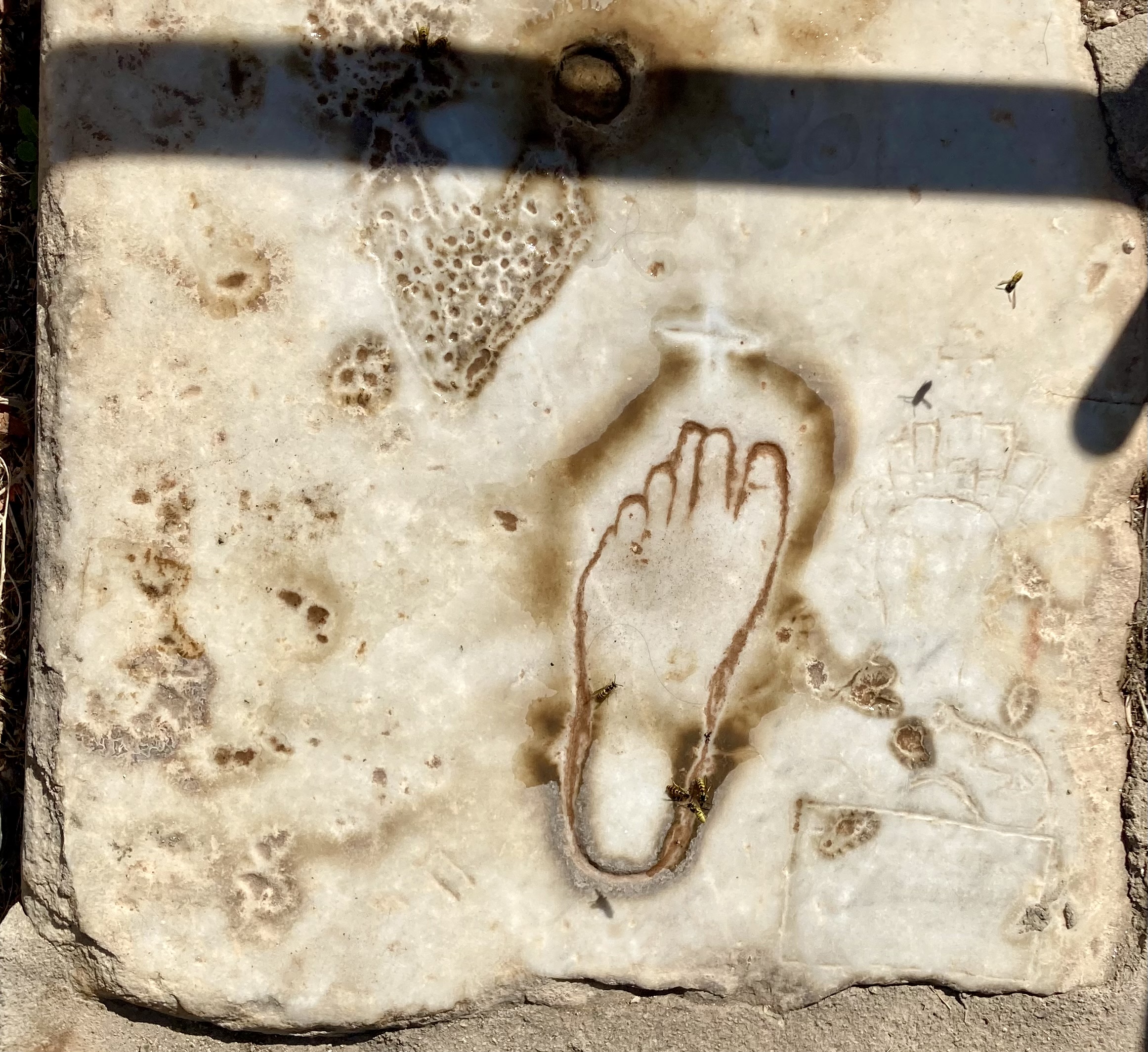
No comments:
Post a Comment